Architects & Engineers

Construction project solutions for architects & engineers

Take concepts off the paper and make them a reality more efficiently and accurately

For those in the Architecture, Engineering, and Construction (AEC) industry, having the ability to take plans and make them a reality requires greater accessibility to project data that is up to date and accurate, to make the right decisions every step of the way until the project is completed.

Multivista is a partner you can rely on to not only capture your project’s as-built conditions using powerful Laser Scanners from our sister company, Leica Geosystems, but we also can help you maximize your point cloud data to gain even more project efficiency.

Our comprehensive suite of reality capture services and solutions will help you whether you’re in the office or out in the field.

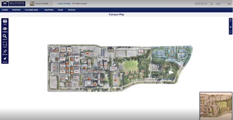
Interactive aerial campus map of BCIT Main Campus by Multivista, showing buildings, roads, and green spaces.

Floorplans, BIMs, and other project information such as Requests for Information (RFI), can be stored on multiple platforms. This segmented approach is not ideal for Architects and Engineers who readily need access to project information to respond to change requests to the plan or prepare properly for Owner/Architect/Contractor (OAC) meetings.

In addition, walking the site to confirm as-built conditions to verify progress, workmanship and adherence to design is a time-consuming process that may not be completed at a regular frequency which can lead to outdated information being used to inform decision making.

Multivista’s platform is a centralized hub for your project’s reality capture and site data that can be accessed by your project’s stakeholders anytime, anywhere. With any device connected to the internet you can virtually walk your site with TruView, our 3D walkthrough software that uses your point cloud data as the roadmap.

Where to start with laser scanning & point clouds

For renovations, as-built drawings or models are crucial as projects can’t start without the correct details in place.

New builds, creating floorplans and utilizing models will allow for not only building more efficiently but will serve to digitize the build for future developments and management needs.

For any project to start off well, regardless of it being a renovation or brand-new build, having the right plans or models in place is key. Each project has its own unique needs and challenges, with Multivista you can choose from a wide variety of solutions to address your project’s requirements.

Complete visibility from every angle

Replacing boilers, refurbishing Mechanical, Electrical and Plumbing rooms (MEP) and other retrofit projects require accurate measurements of the current as-built conditions, and up-to-date plans. For Engineering teams, this information helps them to not only understand what does the current site look like but with point clouds and BIMs they can investigate if new equipment will fit in the space, what piping or other components are connected to, and logistically will equipment need to be disassembled or reassembled through doors.

For any project to start off well, regardless of it being a renovation or brand-new build, having the right plans or models in place is key. Each project has its own unique needs and challenges, with Multivista you can choose from a wide variety of solutions to address your project’s requirements.

A bonus for engineers with laser scanning even in hard to reach or unsafe areas of the site point clouds can be generated with high accuracy. This means no angle or spot will be missed so your teams will have complete visibility of the layout so that you can plan more efficiently.

A global trusted 3D laser scanning and scan to services provider

Our local Multivista teams provide expert services in 3D laser scanning and scan to services. With a vast knowledge and experience, our teams can advise on best practices and methods to effectively digitize your as-built environment to meet your project requirements and solve costly problems.

Thousands of clients worldwide, ranging from small businesses to Fortune 500 companies and government entities, have placed their trust in Multivista to provide 3D scanning services for a variety of use cases.

• Renovation and refurbishment
• Pre-slab & MEP documentation
• Construction verification
• Floor flatness reporting
• Asset management and maintenance

Accredited course provider worldwide

If you’re an architect who needs to earn continuing education credits, Multivista is pleased to offer courses that will provide you with learning more about the power of laser scanning technology or photo documentation. Currently architects who are members of the following can earn credits for participation in our coursework.

  • The American Institute of Architects (AIA)
  • Architectural Institute Of British Columbia (AIBC)
  • Australian Institute of Architects (AIA)
  • Royal Institute of British Architects (RIBA)

To inquire about the Multivista courses and scheduling opportunities,
contact us here.

Trusted by

BCIT has leveraged the Multivista web portal greatly through both this scanning project as well as some live construction webcams we’ve used. It’s very intuitive.

Joe Cosh, Associated Director, Project Services, BCIT

Solid white background

Ready to Start ? Request a Quote