

Better collaboration (remotely) to help teams reduce site visits, resolve issues faster, and prevent costly rework.
As a society, we are accustomed to using technology fueled by real-time data, to save time. We peruse restaurant menus online before deciding where to go, and digital mapping apps show us which travel routes are busiest and suggest alternatives. Surfers use live webcams to check beach and wave conditions before heading out. The same thing, and more, is entirely possible on a construction project.
Using up-to-date, as-built photos and data of exactly what’s happening on site, project stakeholders can walk a jobsite from anywhere, inspect specific areas for issues or to confirm work completed, and even go “back in time” to see exactly how a building has been assembled.
The result is fewer unnecessary site visits, faster decisions, reduced rework, and a better-built project.
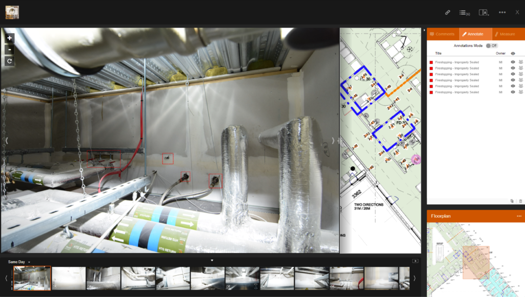
The jobsite is no longer limited by geography
For decades, construction teams have depended on site visits to answer key questions:
- Has the work been completed?
- Was it installed correctly?
- Is the area ready for the next trade?
- What conditions existed before the issue was discovered?
While site visits remain important, they are also expensive. Project managers, owners, consultants, architects, and subcontractors can spend hours driving, flying, coordinating access, and then walking an entire construction site just to answer a question that may take only minutes to resolve.
Modern reality capture changes that equation.
Multivista, part of Hexagon, offers reality capture solutions that create a comprehensive visual record of projects using high-resolution photography, 360° imagery, 3D laser scanning, UAV/drone documentation, video, webcams, and more. These records are organized and accessible through a secure cloud-based platform, allowing approved stakeholders to see exactly what is happening on site from virtually anywhere.
Instead of waiting for the next site visit or relying on second-hand updates, teams can log in, review conditions, and get answers immediately for full project transparency and unparalleled collaboration.
Using reality capture data to collaborate
Reality capture data unlocks the most value when information is shared across the project team. When everyone is looking at the same regularly updated visual record, conversations become more productive, and decisions are made faster and more accurately.
A project manager reviewing progress can direct an architect to a specific room and date. An owner can verify completed work without traveling to the site. A subcontractor can review an installation before dispatching a crew. A general contractor can see exactly what work has been finished for payment applications, or a facilities representative can validate building systems long before turnover.
Rather than exchanging lengthy email chains trying to explain a problem using information that relies on guesswork or memory, teams share “single source of truth” imagery and data to identify the issue visually and agree on a solution. All without booking a meeting in the trailer, or waiting for an important stakeholder who may be out of town.
Find construction site problems earlier. Fix them faster.
On a construction site, reducing physical waste from rework and destructive discovery is always a priority, but wasted time is a problem too. When issues remain unnoticed for weeks or months, the consequences can be significant:
- Rework
- Missed schedule milestones
- Trade conflicts
- Change orders
- Demolition and reconstruction
- Project disputes
Reality capture data – and the ability to share, inspect, and comment on it – helps shorten the time between a problem occurring and a team discovering and fixing it.
By maintaining a consistent visual record throughout construction, project teams can compare current conditions against previous visits, review installations before they are concealed, and verify that work aligns with design intent.
Multivista reality capture creates a time-stamped visual record that helps teams understand what happened, when it happened, and who was responsible. That level of visibility can significantly reduce uncertainty and help teams resolve questions before they become costly problems.
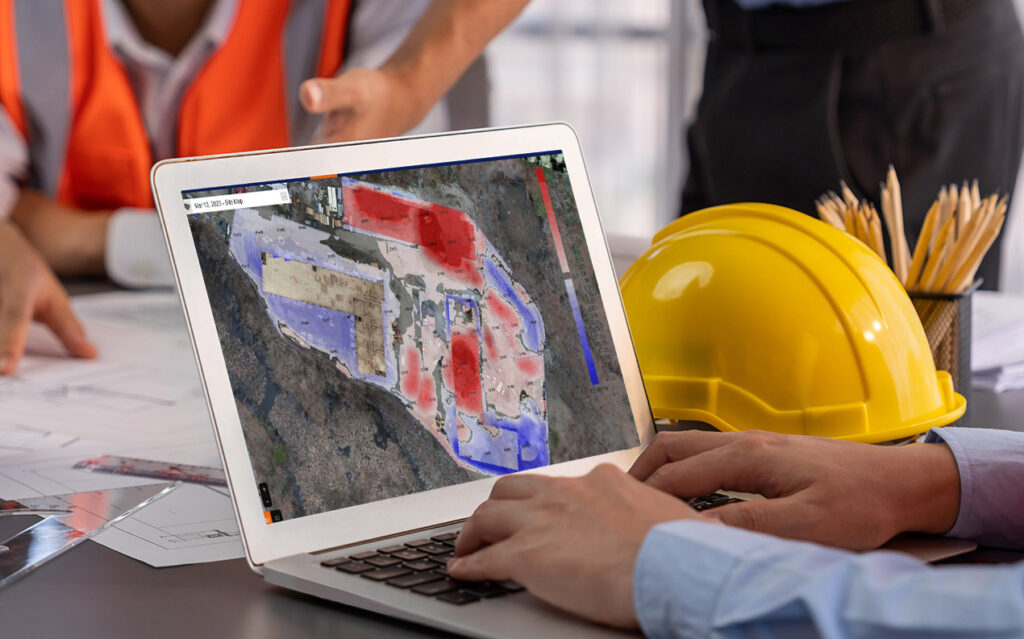
Less time in transit, more time building
Many construction professionals are increasingly responsible for projects spread across wide geographic areas. A project executive may have multiple active sites. An owner’s representative may oversee facilities in several cities. Architects and consultants frequently support projects far from their offices.
Reality capture reduces the need for many of those routine trips. Virtual walkthrough technology allows stakeholders to remotely “walk” a construction site using immersive 360° imagery and digital floor plans. This greatly increases the efficiency of remote management, inspection, monitoring, and validation of as-built conditions.
While virtual access does not eliminate every site visit, it can dramatically reduce the number required simply for information gathering.
Fewer trips mean:
- More productive use of staff time
- Faster responses to project questions
- Reduced travel costs
- Lower environmental impact from vehicle travel
- Improved accessibility for distributed project teams
Sometimes, the most productive site visit is the one you never have to make.
Reducing physical waste through better visibility
Reality capture doesn’t just save travel time, it can also help reduce construction waste.
Historically, when questions arise about concealed conditions, teams often have only two options: make assumptions or start ripping open walls, ceilings, and assemblies to investigate the issue.
Neither option is ideal.
Multivista’s origin story is rooted in solving this exact challenge. The company was founded in 2003 after co-founder Luis Pascual became frustrated by the destructive testing and guesswork required to identify hidden electrical issues and sought a better way to document construction conditions before they disappeared behind finished surfaces.
Luis’ idea of “as-built photos tied to floor plans” pioneered the construction reality capture industry and continues to deliver value.
When teams have access to photographic records, 360° imagery, laser scans, and detailed as-built documentation, they can often verify conditions without demolition. This reduces unnecessary material waste, labor costs, schedule impacts, and disruption to completed work.
The ability to see behind the finished product – because it was documented during construction – can prevent expensive and wasteful discovery efforts years later.
Construction analysis: turning data into actionable insight
There’s another level of efficiency waiting to be unlocked with construction analysis.
Increasingly, owners and contractors want to move beyond documentation and use project data to make better decisions. Multivista’s partners at Hexagon Multivista Analyze services add another layer of value to the jobsite data we collect.
Analyze services transform that reality capture data into objective construction insights through:
- Building Progress Reporting – automated model-to-photo comparisons that generate schedule-based progress metrics on work completed by trade, floor, or area.
- Deviation Analysis – automated model-to-scan comparisons that detect construction deviations and risks.
- Earthwork Progress Reporting – geospatial capture and volume calculations that produce accurate cut-and-fill insights.
Instead of relying solely on manual site walks and subjective observations, teams using Analyze services gain accurate, timely, and objective insight into project performance while eliminating the risks of costly, error-prone manual methods.
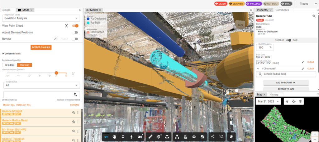
Build better with better information
Construction projects move faster when people have access to reliable information, regardless of their proximity to the actual jobsite.
Reality capture helps provide that information by creating a continuously updated visual record, so teams can review conditions remotely, share information more effectively, identify risks sooner, and make decisions with greater confidence.
The result is less wasted travel, fewer unnecessary site visits, reduced rework, less destructive investigation, and ultimately, better project outcomes. Some site visits can be an email, and the project benefits from that.
To learn more about getting your team set up with Multivista’s remote solutions and reality capture services, reach out for a free personalized demo.